 English
 Français
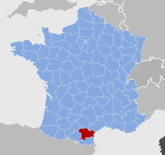
 The two castles of Laroque de Fa
Laroque is one of the many villages in the Corbières with a castle or two. The initial castle was founded on a large rock formation, to this day, known as Castelnaut. The first historical reference to Rocha de fano can be found in The Topographical Dictionary of Aude County in 1215. This rock of the temple equates to a fortified castle; ròca in Occitan means bigger than ròc, which in turn means ‘the big rock’ as òrta means ‘the big garden’ usage and abusage over the centuries has meant that rocky heights and fortification ended up meaning the same thing colloquially. The second reference, again in the 13th century is more specific and cites the Castrum de fano (1258) which up until the 17th century was the only castle in Laroque. In 1261 due to neverending disputes between the Abbey of Lagrasse and Olivier de Termes, the latter sold the village of Laroque to King Louis IX.
In their book ‘Cathar castles…and the others’ Quehen and Dieltiens stress that the ancient castle was made of “two rocky masses linked by typical medieval curtain walls” thus Castelnaut acted as the tower of the castle whilst on the lower north-eastern side the Roc of Peyrot became the casual extension of the edifice. In the Haute-Garronne County archives The Order of Malta Land Registry of 1546 we learn about Jehan soqualha filh de Peyrot de Villa Rouge and in the Land Registry Records of 1585 there is reference to the “l’université de Laroque (i.e. the local community) fait censive annuelle au Roy dix souls tournois… cest pour le fort et chasteau dud lieu maissons que sont dans icelluy”. In this document, the fort means the surrounding walls which include the castle as well as the houses within; there is, for example, “a house within the fort with oven inside run by Jehan Targues et Anthoine Bertrand his brother-in-law”. The 1608 Land Registry stipulates that “at all times the castle of Laroque belongs to his Majesty”. The virtual presence in Laroque of the King of France, distant monarch, ends in 1695 when Bernard de Barre purchased from his Majesty the castles and fiefdom of Davejean and La Roque de Fa.
What about the other Lords of Laroque? There were four from the 13th century onwards. Besides the King himself, two lessser vassals are mentioned towards the end of the 16th and beginning of the 17th centuries; nobleman Jacques de Cazamajou… et nobleman Jehan de Montredon and finally nobleman Brother Claude Daube Knight of the Order of St John of Jeruasalem Commander and Master of dHomp; he too was a vassal of the King of France but as important as the King in terms of local land ownership.
In the 1608 Land Registry, new information, essential to our research, appears. We learn that Master Pierre Villefranque owns “in the barris…a house facing “cers” side (i.e. the wind coming from the west/north-west Narbonne side) the house of the Commander”. The “barris” in Occitan being the various buildings which were outside and thus a prolongation of the castle walls. In this instance on the western and southern sides of the fort and castle, known as the quarter of Carailhé. The first recorded reference to this area appears in 1585 as “a built block of walls at the carralh (which we think must have been Ièro street). Amongst the building outside the castle walls, the jewel in the crown is the Lord Commander’s House. The house of Pierre Villefranque (lots 153 and 154 from the Napoleonic Land Registry, as per our hypothesis) is located between the church in the south and the Commander’s house, which is therefore none other than the modern day castle, in the north-west (lot 150 from the same Land Registry). Another document from de Maltese Archives (side H Malta 5, piece 18), entitled “Financial rents of the members of la Roque de fa, Carcasses, Massac, etc.”, indicates that on the 6th of November 1540 the Lord Commander donated in rent the real estate of the Order of Saint John to Sir Gautier Maurin de Coustouge en Corbiere. It states that this farmer will have to “take on the upkeep and lock the house of la Roque de fa and its windmills which belong to its members”. This is the first mention of the Commander’s house which, we will see, will become the ‘new’ castle. To that effect, the last Land Registry entry from the Maltese Archives dating from 1663, cites “a house in the inner suburbs” facing the NW Narbonne side called “the Commandry”, plus the house of Raymond Villefranque which was also facing the NW Narbonne side called “the castle of the Lord Commander” (both house are located in the block of lots: 143, 144, 145, 146, 148). With this first reference made to “castle” associated with the Commandry the link is then made with the ‘new’ castle. Added to this, in the same Land Registry, at the same time and from henceforth onwards reference is made to the “King’s castle next to the church”.
The 1663 document (side 1 H Malta reg. 1657) provides therefore concrete proof of the existence of two distinct castles in Laroque, the original Royal castle (the tower), remnants of the initial castle on one side and the ‘new’ castle, the old Commander’s house on the other side. This double lordship was a far cry from the 13th century conflicts which opposed the Commander of Laroque’s Templars (predecessors of the Knights of Saint John) and the King of France’s representative, the Lord of Davejean, over the land around Saint-Martin-du-Vilar (now Viala) within the two parishes. The two castles of Laroque-de-fa were and remain historical edifices and symbols of the power struggle between the Church and State.